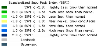
This product is derived from the pan-European Snow Water Equivalent from satellite microwave radiometry blended by snow-measurements from meteorological stations. These products provide information on the relative volume of the snow pack on a 10 daily and 30 daily (monthly) basis, respectively, compared to the reference period 1979 - 2010.
The products cover the region from 72°N/11°W to 35°N/35°E. Pixel size of the products is of the order of 10 to 25 km. The product is available as raster file via the CryoLand GeoPortal.

© FMI ![]()
____________________________________________
Spatial Resolution: 10 km - 25 km
Temporal Frequency: Daily
Data Base: Pan-European Snow Water Equivalent product
____________________________________________